


Scenic off-grid acreage mostly covered with an amazingly lush mature forest. A driveway leads up to a flat open clearing. Zoned Resort Commercial & allows uses such as a single-family home + a secondary dwelling unit, campground, cabins, lodge etc. Drilled well in place. Lake access nearby.
Foreign Buyer Ban does not apply to this property


 +18 photos


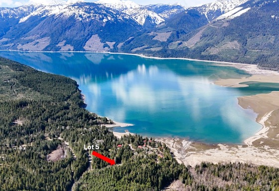
This scenic off the grid acreage (2.52 acres) is mostly covered with an amazingly lush mature forest. This property is part of a small 5 lot strata (no strata fees) perched just up above the lake and located in Beaton, a small off-grid lakeside community in the wild and beautiful Selkirk Mountains.
The land is ready for you to bring your ideas with rare and valuable commercial zoning. The land is part of the CSRD and is zoned Resort Commercial and allows uses such as a single-family home plus a secondary dwelling unit, campground, cabins, lodge and many more options—see zoning section below.
The land has a drilled well and a well-established driveway that leads up to a flat open clearing. Lots of options to build, either tuck a cabin in the woods, build a cabin and big shop in the clearing, or setup a small campground and/or a couple cabins for rent.
Access to the lake is not far away and access to endless backcountry at your doorstep. This tight knit community is one of the best kept secrets in BC.
Call to schedule a viewing today!
281 Jorris Street - Beaton, BC
Off the ferry, drive up the hill a couple kilometres and then turn left on Highwy 31 towards Trout Lake. Drive for approximately 15 minutes and at the end of the road there will be a junction, turn left towards Beaton. Gravel roads from here. Drive another 5 km on maintained roads and then turn right across from the old logging equipment and access Jorris Road.
The last few hundred metres are not Ministry of Transportation (MOT) road and any snow clearing is up to the owner/strata; although the MOT has been plowing to the driveway as there is a better turn around here.
Beaton is a scenic rural community located at the head of the Beaton Arm on Upper Arrow Lake in Selkirk Mountains approximately 50 km south of Revelstoke. This remote area of the Kootenays offers stunning vistas and excellent backcountry recreation with great snowmobiling, lots of options for quads and dirt bikes, robust wildlife viewing, and excellent fishing and boating on the Arrow Lakes. The lake itself is part of the Columbia River Hydro Electric Reservoir. Lake levels fluctuate highly with low water levels in winter (this year has been a very low water year), and peak levels in the summer which lines up well for boating. The Incomappleux River (Fish River) enters the lake nearby the community and the Incomappleux River Valley is home to some amazing inland temperate rainforests. A recently created 58,000-acre conservancy backs onto Glacial National Park—not that far away as the crow flies. Access to this conservancy is very challenging but in close proximity to Beaton and why this area remains relatively intact. Here you can find 1,000-year-old cedar and hemlock trees. There are no commercial services in Beaton, the nearest store/gas bar is 19 km away in Trout Lake. This is an area of amazing geography, a nature lovers/backcountry enthusiast’s paradise.
Visit the Kayak Session website for a video of a kayak exploration down Incomappleux River.
The peak-to-valley landscape along the Incomappleux River is diverse and spans alpine ecosystems, inland temperate rainforest, valley bottom wetlands, streams, and lakes. The Incomappleux River is a major tributary to the Columbia River. The river system supports kokanee salmon and bull trout, as well as plentiful waterfowl and wetland birds.
The forests contain substantial areas of mature and old growth trees, with some ranging from 800 to 1,500 years old. Researchers have identified several at-risk species of plants, mosses and lichen in this valley.
Several species listed on the federal Species at Risk Act are found in the Incomappleux Valley, including two endangered bat species (northern myotis and little brown myotis), southern mountain caribou (threatened) and cryptic paw, a lichen species of special concern.
The northern edge of the Incomappleux Valley project area abuts Glacier National Park, increasing important habitat and landscape-level connectivity for wide-ranging animals across the southern interior mountains of BC.
The project area includes 58,000 hectares which is now designated as a provincial conservancy, plus an additional 17,000 hectares that is protected from commercial timber harvest.
In 1896, the steamboat landing became the eastern terminal for the Arrowhead-Beaton Ferry. Formerly Thomson's Landing, it was named after the landowner, James William Thomson, who was the local notary public in 1901. Thomson's subsequent partner was Malcolm Beaton. In 1902, the name changed to Beaton. There were 65 residents in 1911. Other towns in the vicinity included Comaplix, Camborne, Galena Bay and Arrowhead. In 1957, the eastern terminal for the ferry moved to Galena Bay. As BC Hydro was flooding the new reservoir in 1967-1969, the hotel burned to the ground. The post office closed in 1969. Although comprising several scattered residences, the former settlement was mostly covered by the reservoir and never rebuilt. Beaton is now home to a handful of residents and several more recreational/seasonal property owners.
A very cool local dive site . . . the largest inland wreck site in BC is nearby the property.
The Bonnington was a sternwheel steamboat that ran on the Arrow Lakes from 1911 to 1931. Bonnington and two sisterships were the largest sternwheelers ever built in BC. Over the course of a number of years, the Bonnington was partially dismantled at Beaton, and in 1960 the hull filled with water and sank near the shore. In the 1990s, the wreck was located and explored by members of the Underwater Archaeology Society of British Columbia and found to be remarkably intact. The Bonnington is the largest freshwater shipwreck site in British Columbia. In the words of historians Parent, Bouliane, and Bouliane: Though the Bonnington has been stripped down to a bare hull, the Queen of the Southern Interior steamboats is still an impressive sight. She lies in her final resting-place at the end of the secluded Northeast Arm, where the once thriving community of Beaton once stood and is now also just a memory.
Please see the mapping section for maps and plans, all boundaries are approximate.
50°44'18.87"N and 117°43'26.29"W
Zoning allows uses from single family, secondary dwelling unit to resort uses such as campgrounds, lodge/hotels, tourist cabin, etc.
Lots of amazing timber to be used for building materials.
Bare land, driveway cut into land.
The property is in the Columbia Shuswap Regional District.
Resort Commercial (RC1)
Principal Uses
Campground, convenience store, day care, gas and fuel sales, hotel, helipad, lodge, marina, motel, pub, public assembly facility, restaurant, single family dwelling, skiing facility, tourist cabin.
Accessory Uses
Accessory use, home occupation, secondary dwelling unit, staff accommodation.
STRATA LOT 5, DISTRICT LOT 502, KOOTENAY DISTRICT STRATA PLAN EPS7778, TOGETHER WITH AN INTEREST IN THE COMMON PROPERTY AS SHOWN ON THE STRATA PLAN
PID 031-935-613
 +8 maps


Our property descriptions and geographical information are taken from the BC Assessment Authority, Land Titles Office, government maps and other sources. While LandQuest® does not guarantee the information, we believe it to be accurate, but should not be relied upon without verification. This communication is not intended to cause or induce breach of an existing agency agreement.
Revelstoke
 9℃
9℃
 7℃
7℃